Object Record
Images
Metadata
Object ID |
2020.007.003 |
Object Name |
Plat, Survey |
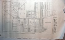
Description |
Copy (maybe a photocopy) of a 1900 plat of survey for parts of Wilmette and Gross Point. Black line printing on white paper. The plat's legend reads: "Village of Wilmette / 1900 (06) - Gross Point / Wilmette / Scale: [shows a ruler of 0 to 500 feet]." The plat may be of Wilmette's Section 33, as indicated by a small notation near the bottom of the drawing. It shows the area immediately east and west of Ridge Road from about the Kenilworth / Winnetka border on the north to about the Evanston / Skokie border on the south, and from 15th Street on the east to probably Hunter Road on the west. In the area around Illinois Road and Old Glenview Road, there are names of property owners on the acreage, presumably farms. These names are the same as on 2020.007.001. Much of the rest of the plat shows the land subdivided into lots, but there are no names attached to the lots except at Ridge, just east of Lake Avenue on the east or Wilmette side of the street - from Lake Avenue, they are Paul Hunter, John Schwall, J.P. Schwall, Simon Schwall, and Mary Schwall. However, the plat also shows the presence of buildings at the intersection of Ridge Avenue and Gross Point Road (now Wilmette Avenue) and at and near the intersection of Lake Avenue and Ridge showing buildings on the west or Gross Point side of Ridge south of Lake, and on the southeast corner (presumably St. Joseph Church Rectory), as well as a few other buildings along Ridge Road, including two greenhouse complexes, one on the R. Nanzig property (spelled Nantzig) and one farther south, probably on Hoffmann property. Some of the streets are labeled with the street name and others are not labeled. |
Date |
1900 - 1906 |
Classification |
Agriculture Farms Gross Point, Village of Wilmette, Village of |