Object Record
Images
Metadata
Object ID |
2020.007.001 |
Object Name |
Plat, Survey |
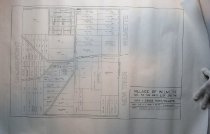
Description |
Copy of an 1873 plat of survey for Gross Point and Wilmette. White paper with black lines, a copy purchased from the Cook County Recorder of Deeds. Plat legend reads, "Village of Wilmette / Sec. 33, T42 NR 13 E. of 3rd PM / 1873 - Gross Point / Wilmette / Scale 1/4" = 1 chain = 66' 0" / Notes: Property layouts from Cook County Deeds Records (outline based on 1877 plat)". The plat shows the main streets of Gross Point Ave (later Wilmette Ave.), Ridge Ave., Lake Ave., and a small section of Old Glenview Road (not labeled). The plat also shows the names of the property owners on their plot of land, including the following last names: Schaeffer (Schaefer?), Blaser (Bleser?), Klein, Roemer, Meyers, Steffens, Heaber, Ault (Alt?), Sisterhenn (Sesterhenn?), Hanson, Hoffman, Fisher, Castor [Kaster], Schram, Scheffens (Schaefgen?), Meiers, Bauer, Keil, Peyo, Mantzig (Nanzig?), Kohl, Kaiser, Hartman, Schaefien (Schaefgen?), Kloefer (Kloepfer?), Blum, Pasbach, Reinert, May, Schwall, Bartz. The survey appears to include 15th Street on the east to Hunter Road on the west, and Lake Avenue on the north to Central Street, Evanston, on the south. Springer's Addition to Wilmette and Seger's Subdivision are also outlined on the map. |
Date |
1873 |
Classification |
Agriculture Gross Point, Village of Real Estate Wilmette, Village of |